| The 1740 map shows that the site was called ‘Phelp’s but it was occupied by Thomas Jones. |
| The 1740 and 1766 ledgers show that the Royal Oak was on a site that was ‘ex Blackmans’ and the lease was owned by the Culliford family. The 1740 map also shows two buildings call Old Ford Farm Building 1 and Old Ford Farm Building 2 which may have been the Royal Oak or a mill. |
 The 1794 map confirms that there was something on the site at the time which could be the building seen at the rear today. The 1794 map is generally quite reliable about showing where buildings were but it was not very accurate about the dimensions of buildings. The map identifies a cottage at the bottom of Chew Hill as the Royal Oak but that may just have been a cottage that formed part of the holding of the Royal Oak. Most of the inns had land that was used to sustain the innkeeper and his or her family. The 1794 map confirms that there was something on the site at the time which could be the building seen at the rear today. The 1794 map is generally quite reliable about showing where buildings were but it was not very accurate about the dimensions of buildings. The map identifies a cottage at the bottom of Chew Hill as the Royal Oak but that may just have been a cottage that formed part of the holding of the Royal Oak. Most of the inns had land that was used to sustain the innkeeper and his or her family. |
 The 1841 census records that John Parfitt was living in Blackmans and he was the Waldgraves land agent so he may have been involved in constructing the more prestigious house that is seen from the front. The 1871 census shows that John James Habgood was the tenant of Blackmans Farm whilst William Mitchell was the Estate Agent living in Blackman’s Cottage which is a rather humble name for such a fine house but what was known The Old Vicarage was known as Navestock Cottage when it was occupied by the Estate Agent in 1904. The 1841 census records that John Parfitt was living in Blackmans and he was the Waldgraves land agent so he may have been involved in constructing the more prestigious house that is seen from the front. The 1871 census shows that John James Habgood was the tenant of Blackmans Farm whilst William Mitchell was the Estate Agent living in Blackman’s Cottage which is a rather humble name for such a fine house but what was known The Old Vicarage was known as Navestock Cottage when it was occupied by the Estate Agent in 1904. |
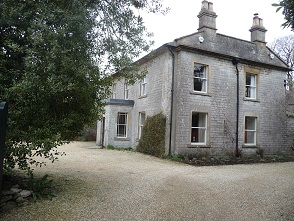
 Walderave House is in Lower Street on the Litton Road. It is designed to be seen from the front but the rear view gives a better understanding of its history. As the name suggests, it was Waldegrave property but the historic records suggest it was a farm known as Blackmans . There may have been fields and possibly other places known as Blackmans in the past but there is strong evidence that this was the site of Blackmans from the middle of the 18th century.
 The 1841 census records that John Parfitt was living in Blackmans and he was the Waldgraves land agent so he may have been involved in constructing the more prestigious house that is seen from the front. The 1871 census shows that John James Habgood was the tenant of Blackmans Farm whilst William Mitchell was the Estate Agent living in Blackman’s Cottage which is a rather humble name for such a fine house but what was known The Old Vicarage was known as Navestock Cottage when it was occupied by the Estate Agent in 1904.